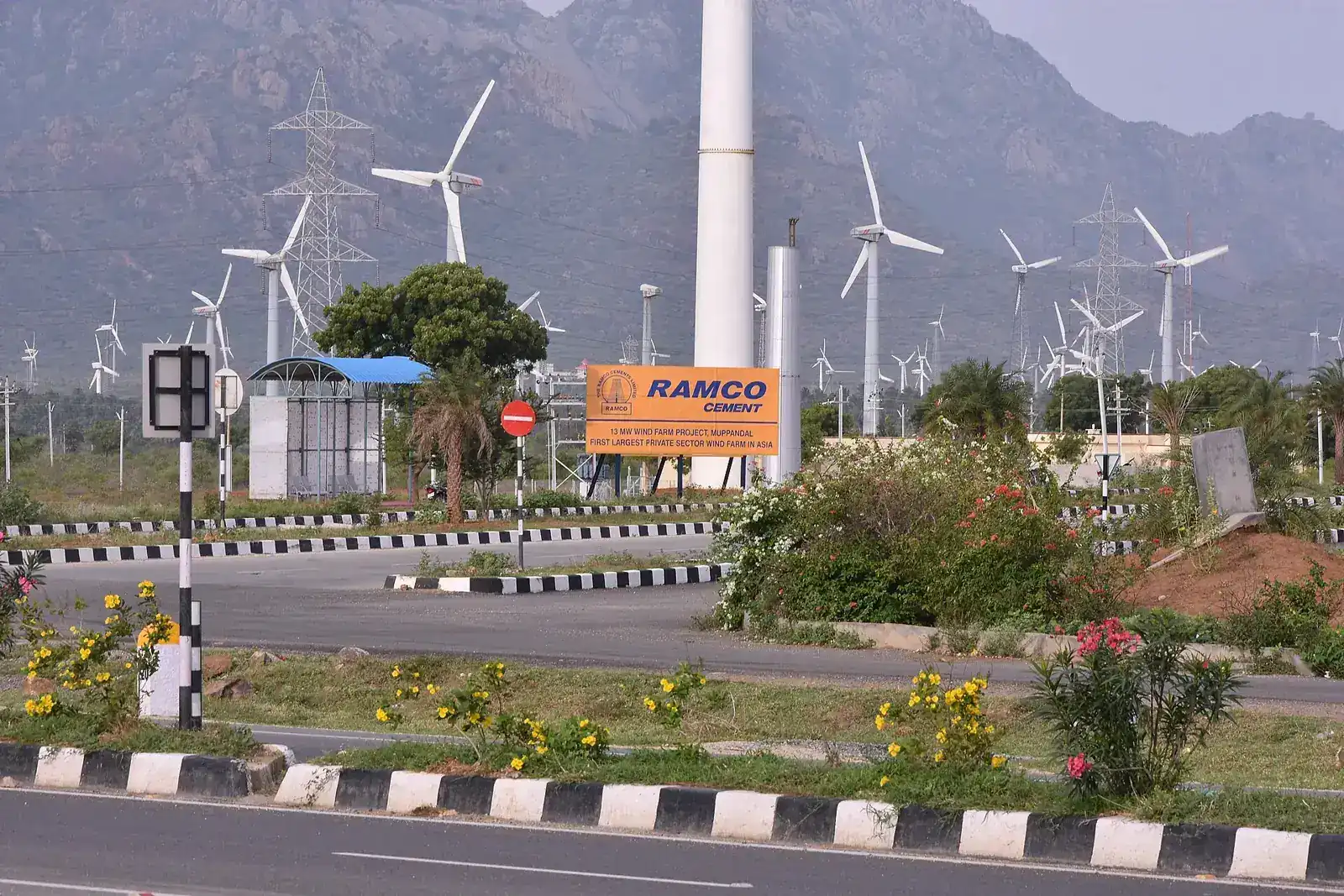
Thousands of turbines catching the gap in the Ghats
Somewhere around twenty-five to thirty kilometres from Kanyakumari, on the road toward Nagercoil near Aralvaimozhi, the land opens up and the horizon fills with turbines — thousands of them, spread across the plain in a field that ranks among the largest onshore wind installations in Asia. The turbines exploit the Aralvaimozhi gap, a natural break in the Western Ghats that channels wind from the interior toward the coast with unusual consistency, which is exactly why this particular stretch of flat land was chosen for wind power development starting in the 1980s and expanded heavily since.
This is not a ticketed attraction with a visitor centre or a formal viewing area; it is a roadside sight, seen from the highway itself or from a handful of informal pull-offs where drivers stop for photographs. The scale is the point — turbine after turbine stretching to the horizon rather than any single structure worth a dedicated stop. The wind is genuinely strongest between June and September, the south-west monsoon months, when the blades turn fast enough to be visibly different from the slower rotation seen in the dry season, and this is the best time to appreciate why the site was chosen in the first place.
Why Muppandal and not somewhere else
The Aralvaimozhi gap is a natural break in the Western Ghats mountain chain, and gaps like this act as wind funnels, channelling air from the interior of the peninsula out toward the coast with far more consistency than open, unbroken terrain provides elsewhere. This is the underlying reason wind power development concentrated so heavily around Muppandal from the 1980s onward, well before wind energy became a mainstream part of India’s power generation strategy, and the district’s topography rather than any policy decision alone explains why this specific stretch of Tamil Nadu became one of the country’s earliest and largest wind energy hubs. The consistency of the wind here, rather than its peak strength on any single day, is what makes the site genuinely productive across the year, and it is a useful example, for anyone interested in renewable energy, of how geography rather than technology alone determines where large-scale wind power actually works.
What you actually see from the road
There is no formal viewing platform or visitor centre, so the experience is entirely a roadside one: turbines visible from the highway itself, some close enough to the road to see clearly, others receding toward the horizon in every direction across the flat plain. A handful of informal pull-off points along the route let drivers stop safely for photographs, though none of these are marked or maintained specifically for tourism, so use ordinary caution parking on a working highway. The genuine draw is scale rather than any single turbine — the sense of thousands of these structures spread across a landscape rather than a cluster of a dozen — and photographs rarely capture that sense of scale as well as simply looking out across the plain in person does. Fifteen to twenty minutes at a safe pull-off is enough for most visitors; this is a sight to note while passing through rather than a destination requiring a long, dedicated stop.
When the wind is actually worth seeing
Between June and September, during the south-west monsoon, wind speeds across this stretch pick up considerably, and the turbine blades turn visibly faster than during the drier months, giving a clear sense of why this exact gap in the Ghats was chosen for development in the first place. Outside this window, particularly in the calmer months around February and March, a good number of turbines turn slowly or barely at all, and the site can feel underwhelming to visitors expecting constant, dramatic motion regardless of season. If your trip falls in the June to September window, a stop here genuinely earns its place on the itinerary; if it falls in the calmer months, treat it as a pass-through sight seen from the car window on the way to or from Nagercoil rather than a stop that needs dedicated time set aside for it specifically, and save the enthusiasm for a season when the blades are actually turning.
Combining it with the road to Nagercoil
Muppandal sits directly on or near the main road between Kanyakumari and Nagercoil, which most visitors are travelling anyway to reach the Nagaraja Temple, the railway station, or onward connections toward Trivandrum. This means the wind farm rarely needs a special detour; it is seen naturally as part of a drive already being made for other reasons, and a short pull-off stop of fifteen minutes adds very little to a journey already covering this stretch of road. Our drivers know the safer pull-off points along the route and will stop briefly without it disrupting a wider day’s schedule, since this is one of the few sights in the district that costs almost no extra time to include. It works well bookended between a temple stop and a return to Kanyakumari, breaking up a longer drive with something to look at that is entirely different from anything else on the itinerary.
Honest expectations
This is a drive-past sight, not a destination with facilities, signage or a formal stopping point, and visitors expecting an organised viewpoint or an interpretive centre explaining the wind farm’s history will not find one here. What it offers is genuinely striking in the right season — the sheer number of turbines stretching across the plain is unlike anything else in the district — and genuinely underwhelming in the wrong one, when the blades barely turn and the plain looks simply flat and industrial rather than dramatic. Photography from a moving vehicle rarely does it justice; a brief, safe stop at a pull-off is worth the few minutes it costs. Set expectations around season rather than around the site itself, and this remains one of the more distinctive short stops on the route toward Nagercoil, particularly for anyone who has not seen a wind farm at this scale before and has no comparable sight nearer home.
Six things our drivers tell every guest
- Visit between June and September for the strongest winds and the most visibly active turbines.
- There is no visitor centre — this is a roadside sight seen from the highway or informal pull-offs.
- Photographs from a moving car rarely capture the scale; a brief, safe stop is worth it.
- Outside the monsoon months the blades turn slowly and the site can feel underwhelming.
- It sits on the road to Nagercoil, so it rarely needs a dedicated detour of its own.
- Use ordinary caution parking at any pull-off — none are specifically marked or maintained for tourists.
How to get here
Muppandal Wind Farm is 25 to 30 km from Kanyakumari town, 45 min by road. It is included in our one-day sightseeing package and our temple circuit package, or we can add it to any local sightseeing day by the hour.
Questions about Muppandal Wind Farm
Nearby places to add to the same day
 20 km
20 kmNagaraja Temple
Nagaraja Temple gives Nagercoil its name and its sand-floored sanctum. 20 km from Kanyakumari, its architecture shows unusual Jain and Buddhist influence.
 12 km
12 kmThanumalayan Temple
Suchindram’s temple has four musical pillars carved from one stone and an 18 ft Hanuman cut from a single granite block, 12 km from Kanyakumari.
 7 km
7 kmVattakottai Fort
An 18th-century granite sea fort 7 km from Kanyakumari, built under Marthanda Varma’s Dutch commander De Lannoy, ASI-protected, best seen late afternoon.
Want Muppandal Wind Farm at the right hour?
We know when the queue is short and when the light is good. One message and it is in your plan.